
Navigation » List of Schools, Subjects, and Courses » Geog 001 – Physical Geography » Quizzes » Chapter 1 Quiz
With Answers Good news! We are showing you only an excerpt of our suggested answer to this question. Should you need our help in customizing an answer to this question, feel free to send us an email at  or chat with our customer service representative.
Chapter 1 Quiz
Chapter 1 Quiz
1. The 0° Meridian is the same line as the ________.
International Date Line
Prime Meridian
equator
geographic grid
perihelion
2. The first nearly correct measurement of the Earth’s circumference was made ________.
by satellite
about 2,200 years ago
by Italian scholars during the Renaissance
by the first humans
by Columbus
3. The United States spans ________ time zones.
12
24
36
3
6
4. The perihelion is during the month of ________.
January
September
December
July
March
5. This figure shows the position of Earth relative to the sun during solstices and equinoxes, during the orbit of Earth around the Sun.
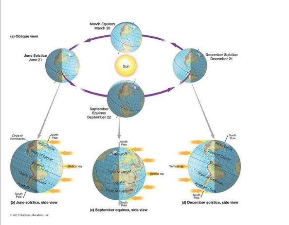
This figure shows that the most fundamental cause of the annual march of seasons is that ________.
the orientation of the North Pole changes with respect to the sun
the yearly solar energy totals vary by hemisphere
December has the shortest day lengths in the Southern Hemisphere
the northern end of Earth’s axis is oriented towards the sun all year
March has the longest day lengths in the Northern Hemisphere
6. Earth systems resist change but there are times when the system can change abruptly or become unstable. This is known as a ________.
tipping point
equilibrium condition
quantum moment
human mistake
negative feedback loop
7. The ________ is the environmental sphere that encompasses water in all its forms and locations.
atmosphere
hydrosphere
geosphere
biosphere
lithosphere
8. The elements of geography can be grouped into two categories ________.
human geography and physical geography
weather and climate and geology
plants and animals
landform geography and political geography
economic activities and physical geography
9. In the Northern Hemisphere in July, day lengths are ________ as one travels from the equator to the North Pole.
the shortest of the year
progressively longer
the longest of the year
unchanged
progressively shorter
10. The Earth cut in half through the poles, and cut it half at the Equator. The polar and equatorial diameters are different in size.
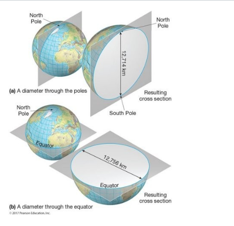
This figure shows that Earth is ________.
round
an ellipsoid
an oblate spheroid
solid in its middle
flat
11. Which of the following statements is out of order in the ideal application of the scientific method?
Observe the outcome of an experiment.
Design an experiment.
Make a hypothesis.
Observe a phenomenon that stimulates a question.
Formulate a rule.
12. If the axis of the Earth were not tilted, Earth would not experience ________.
aphelions
day/night variations
seasons
rotation
perihelions
13. The world is divided into ________ standard time zones.
24
360
11
180
15
14. Which of the following best describes the latitude and longitude of North America?
Northern and western hemispheres
Northern and eastern hemispheres
Eastern and southern hemispheres
Northern and southern hemispheres
Eastern and western hemispheres
15. Which of the following would NOT be a major topic taught in a course of introductory physical geography?
Landforms
Climate
Population
Plants
Soil
16. The fact that at any time during the year, the Earth’s axis is parallel to its orientation at all other times is called its parallelism, or ________.
aphelion
perihelion
revolution
polarity
rotation
17. Geography is ________.
much the same as geology
a physical science
a social science
a combination of physical and social sciences
an art, not a science
18. The geographic grid line 180 degrees of longitude from the Prime Meridian is the ________.
90th meridian
Tropic of Capricorn
320th meridian
Tropic of Cancer
180th meridian
19. The International Date Line ________.
is the “baseline” for all time measurements
passes through the United States
is the same line as 180 degrees latitude
is drawn to avoid countries
is an important line of latitude
20. The solid, inorganic portion of the Earth system is known as the ________.
hydrosphere
lithosphere
biosphere
atmosphere
Earth
21. This figure shows a view of Earth from above the North Pole with meridians labeled.
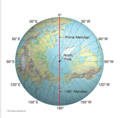
This figure shows a view of Earth from above the North Pole with meridians labeled. Meridians are also known as ________.
axes
lines of longitude
parallels
diverging parallels
planes of the ecliptic
22. The Earth-Sun aphelion occurs once per year during the month of ________.
December
September
January
March
July
23 The highest numbered latitude used in the geographic grid is ________.
180°
90°
100°
45°
360º
24. How many degrees of latitude are there between the Tropic of Cancer and the Tropic of Capricorn?
23.5
180
0
90
47
25. “Greenwich Mean Time” is also known as ________.
European time
the plane of the ecliptic
Universal Time Coordinated
Polaris
the perihelion