
Navigation » List of Schools, Subjects, and Courses » Geog 001 – Physical Geography » Quizzes » Chapter 9 Quiz
With Answers Good news! We are showing you only an excerpt of our suggested answer to this question. Should you need our help in customizing an answer to this question, feel free to send us an email at  or chat with our customer service representative.
Chapter 9 Quiz
Chapter 9 Quiz
1. The top of the saturated zone of ground water is called the ________.
vadose zone
waterless zone
aquiclude
zone of saturation
water table
2. Which seawater has been found to have the least density?
Seawater near the bottom
Surface seawater in warm regions
Sinking seawater
Saltier than average seawater
Surface seawater in a cold region
3 The hydrologic cycle is considered a(n) ________ system
blue-colored
infinite
collapsing
open
closed
4. In Las Vegas, Nevada, the groundwater supply is ________.
not being used and staying the same
being depleted
increased
about to be tapped as soon as Lake Mead runs dry
being used and staying the same
5. Our knowledge of the oceans is ________.
fairly limited until recent decades
now complete
equal to our knowledge of the continents
unimportant because humans live on the land
never going to amount to much
6. Rock through which ground water cannot run or flow is a(n) ________.
vadose layer
aquiclude
aquifer
phreatic layer
groundwater layer
7. Of the following, which is energized by the wind?
Deep ocean circulation
Tidal bores
Tides
Ocean currents
The cryosphere
8. A chunk of independently floating ice is an ice ________.
pack
berg
shelf
chunk
floe
9. Of the Earth’s water inventory, most of the fresh water is stored in the form of ________.
water in lakes
soil moisture
glacial ice
condensation (clouds)
river and stream water
10 The figure shows an ocean bounded by India, Africa, Asia, and Australia.
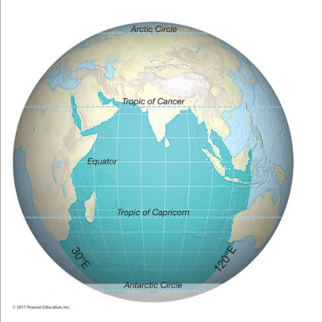
The ocean shown in this figure is the ________ ocean.
Pacific
Arctic
Atlantic
Southern
Correct!
Indian
11. Oceans are becoming more acidic because they are absorbing ________.
lye
smoke
carbon dioxide
hydrochloric acid
rocks
12. The figure shows a cross-section through rock structures related to aquifers. There are five layers.
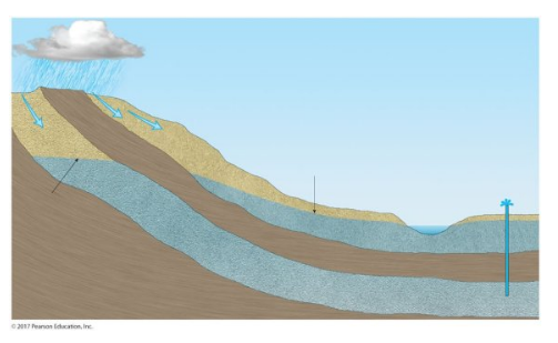
There are five layers shown and the second and fourth from the top are aquifers in which water has accumulated. The first layer under Earth’s surface and above the aquifer layer is best termed the ________.
aquiclude
groundwater zone
waterless zone
water table
zone of aeration
13. The global oceanic conveyor belt circulation has prominent areas of sinking in the ________ Ocean.
South Pacific
North Atlantic
North Indian
South Atlantic
North Pacific
14. The deepest oceanic trenches are in which ocean?
Arctic
Atlantic
Indian
Pacific
In the Atlantic, Pacific, Artic or Indian, the trenches are approximately the same depth.
15. Which force supplies the energy for percolation?
Coriolis force
Hydraulic head force
Gravity
Capillary force
Pressure gradient
16. Geographically speaking, the most important currents ________.
involve upwelling
are caused by tides
involve subsidence
are the flows making up the oceans’ general circulations
are caused by underwater earthquakes
17. The movement of a wave across the surface of the ocean is a movement of ________ rather than matter.
time
wind
water
substance
energy
18. Of the places listed below, ocean waters generally have the least salinity in ________.
places with lack of rainfall
small seas and gulfs
subtropical zones
polar regions
hot places
19. In the oceans, place-to-place differences in water temperature and other characteristics are most prominent ________.
at the bottom
near the surface
in tropical latitudes
at depths below a few hundred meters
in polar latitudes
20. Which of the below best describes water moving through Earth material because of the influence of gravity?
Flow
Capillary action
Evapotranspiration
Percolation
Subartesian
21. North America’s largest lake is ________.
Lake Erie
Great Salt Lake
Great Bear Lake
Great Slave Lake
Lake Superior
22. Water not found in oceans accounts for ________ percent of the world’s total water.
2.8
28
74
56
0.25
23. Surface water occupies somewhat more than ________ percent of our planet.
70
50
10
99
90
24. Most of Earth’s water is stored ________.
on the surface in solid form
underground in liquid form
as capillary water in the soil
in gaseous form
on the surface in liquid form
25. The oceans contain approximately ________ percent of all water on Earth.
0.7
97
57
17
77